
SwellMap: New Zealand’s only hazard forecast for rock or land-based fishing
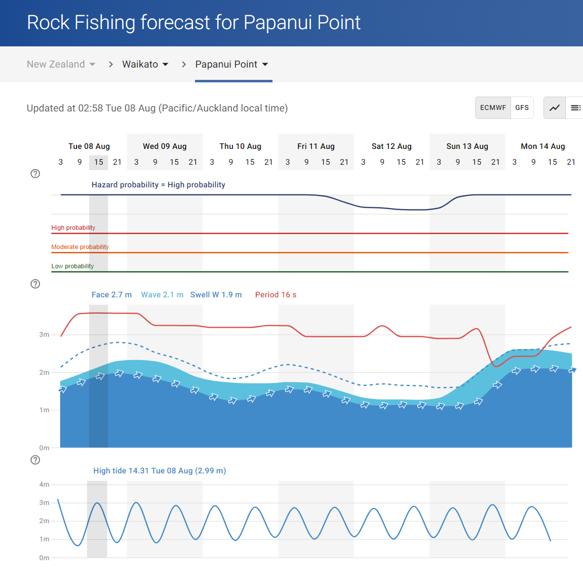
Example of SwellMap rock fishing hazard forecast.
Rock fishing has become a popular recreational activity. However, it is unfortunate that an average of four rock fishers drown each year due to being swept off the rocks by large waves (Surf Life Saving NZ) and is considered one of the most dangerous recreational activities in New Zealand (Drowning Prevention Auckland).
Based in Raglan on New Zealand’s wild west coast, the team behind SwellMap have previously had, through working as volunteers in the NZ Coastguard, firsthand experience in search efforts for land-based fishers lost at sea off Papanui Point south of Raglan. More than 30 people have died fishing off Papanui Point, according to the Department of Conservation.
Experiencing the heartache associated with these losses as a small community and as first responders within Coastguard; with the help of Maritime NZ and Surf Life Saving NZ (who provided timing and location data on fatal and non-fatal incidences) as well as data from Australian incidents, we took it upon ourselves to apply our ocean knowledge and data processing skills to derive New Zealand’s only hazard forecast for Rock or Land Based Fishing.
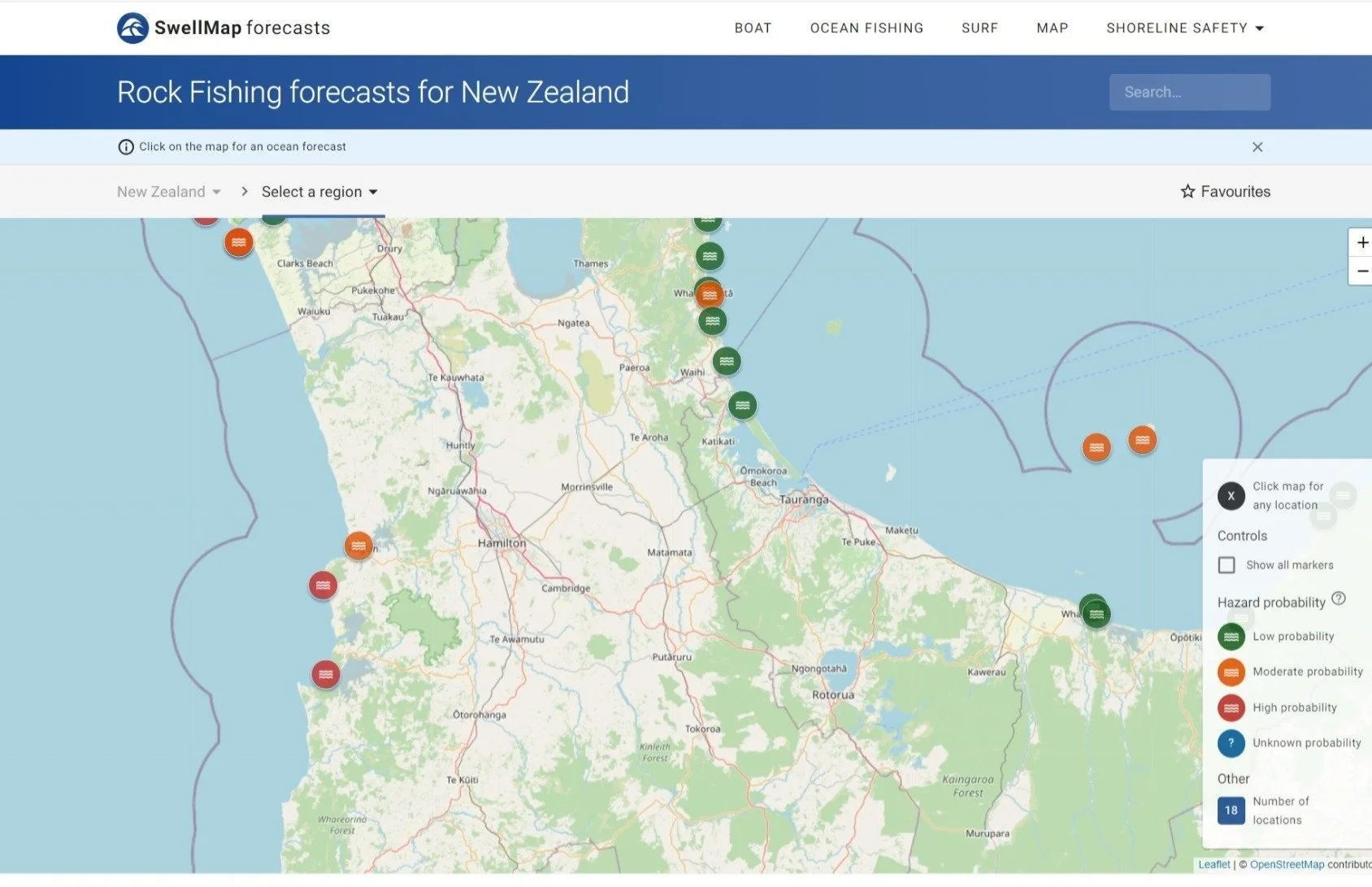
SwellMap provides a forecasted rating system that informs users of the conditions for their chosen activity. In the above image, rock fishing hazard forecasts are rated low, moderate or high. Users can now click on the map to generate a forecast for that specific location.
The Rock Fishing Hazard forecast considers wave heights, periods and tidal conditions and shows the probability of encountering hazardous conditions while undertaking Land-Based Fishing and Rock Fishing activities. These can be surgy conditions related to long period swells or rising tides potentially catching out unsuspecting fishers, and at the time of the incident very hazardous conditions were forecast for Papanui Point - correlating with an incoming tide, rising swell and a jump in the wave period – all factors that lead to an increase in the danger.
These hazard forecasts are public and free and provided on the website Swellmap. SwellMap leverages MetService’s bespoken products and services, including the Point Forecast API and the Tiles API to generate derived specific forecasts. If you're unable to locate your fishing spot from the list, you can easily navigate the map, click on your desired location, and access the hazard forecast report – no giving away secret spots
We recognise that each fishing site is unique, and each will have its specific hazards. The hazards forecast we are providing relates only to the ocean conditions. Nothing beats experience, but experience can also lead to complacency - so always take care and be observant of your surroundings.
If in doubt don’t go, here are some of Surf Life Saving NZ recommendations to stay safe when rock fishing:
Wear a lifejacket
Pay particular attention to swell and tide information.
Never fish in exposed areas during rough or large seas
Spend at least ten minutes observing the sea conditions before approaching the rock ledge
Never turn your back on the sea
Pay attention to warning signs
Never fish from wet rocks where waves and spray have obviously been sweeping over them.
Also, check out the Safer Rock Fishing module by Drowning Prevention Auckland at https://www.dpanz.org.nz/courses/safer-rock-fishing/
Contact us for more information at feedback@weathermap.co.nz