
Tracking a lost sailing yacht

Jolly Rogers adrift in the Atlantic.
At the end of October, MetOcean Solutions helped an insurance company find a missing yacht that had been drifting for weeks in the Atlantic Ocean.
Pantaenius, the global yacht insurance company, were trying to help find a yacht abandoned during the Mini Transat 6.50 race. This solo race across the Atlantic Ocean, held every two years, sees sailors brave the roughly 4000 miles from France to the Caribbean only stopping in the Canary Islands on the way.
The yacht was Jolly Rogers, a MINI 6.50 (a 6.5 m high-performance sailing vessel), which had been abandoned on 5 October off Spain’s Cape Finisterre when persistent technical issues caused the sailor Luca Sabiu to set off his distress beacon. Luca was airlifted out by helicopter by the Spanish navy, leaving Jolly Rogers adrift.
The yacht was considered lost at sea until a sighting on Friday 20 October provided a position when preparations were made to start a salvage operation. The weather was closing in, however, with forecasts promising strong winds and wave heights in excess of 6 m. Worried that the boat would have drifted too far to be found by the time the weather settled down, Olivier de Roffignac from Pantaenius contacted MetOcean Solutions for advice on where the boat would drift to over two to three days of high winds and heavy seas.
“Searching for a 6 m sailboat in the Atlantic Ocean is a bit like looking for a needle in a haystack,” explains MetOcean Solutions’ oceanographer Simon Weppe, based in France. “Salvage operations are costly, and Pantaenius wanted guidance on the likely drift track of the boat so that they could narrow down the search radius when the weather was calm enough to initiate the search.”
“To help Pantaenius we modelled the predicted drift of the vessel, continuously updating our predictions as new forecast cycles became available. To account for the uncertainties in the drifting behaviour of the boat, we ran simulations affording different importance to windage (wind-related drifting).
“The global models differ somewhat, and so to get the best results we used several different forecast datasets for winds and currents: the European Centre for Medium-Range Weather Forecasts (ECMWF) winds and MERCATOR currents*, and the US National Oceanic and Atmospheric Administration (NOAA) Global Forecasting System (GFS) winds and Real-Time Ocean Forecast System (RTOFS) currents.

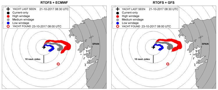
Jolly Rogers was found only a couple of miles from the predicted location when using ECMWF winds and Mercator currents.
“We found a large variability in the predicted tracks depending on which current data we used. In this location, MERCATOR currents and the ECMWF winds yielded the best predictions. The salvage operation was launched on Monday 23 October, and the yacht was found 2-3 miles from the location we predicted, which is very encouraging given the many uncertainties.
“In this case, getting the current-related component of the drift was important because the yacht had sails and rigging dragging in the water, which would have acted as a sea anchor. In that region of the world, the MERCATOR currents are obviously more accurate than the RTOFS ones”.
The case highlights the importance of using several data sources and drifting model setups for situations where there is limited data on the drifting characteristics of the object lost.
Our team of experienced modellers is able to quickly simulate the drifting trajectory of anything lost at sea - including vessels, personnel, and oil spills. By using different global datasets we can model a suite of possible trajectories, and compare the outputs, providing the best possible guidance for our clients.
“In the past, we have assisted clients by modelling the trajectory of oil spills, the spread of invasive species, and the dispersal of rubbish in the ocean. It is great that we could assist Pantaenius find the yacht.”
For more information about how we can assist with trajectory modelling, contact us at enquiries@metocean.co.nz.
* All MERCATOR current datasets (and more) can be accessed freely via The Copernicus Marine Environment Monitoring Service. The Copernicus Marine Environment Monitoring Service provides Full, Free and Open Access to Data & Information related to the Global Ocean and the Marine Environment.