
Storm Warning: Are We Ready for New Zealand’s Rising Ex-Tropical Cyclone Threat?
With ex-TC Vaianu to track toward New Zealand and set to impact much of the North Island this Sunday, a familiar question resurfaces, are we truly prepared for the growing threat of these events? Following significant storms like ex-tropical cyclone Gabrielle in 2023, concerns are mounting about whether we fully understand the risks posed by increasingly frequent and intense ex-tropical cyclones.
New Zealand has experienced a noticeable increase in the frequency and intensity of storms and tropical cyclones in recent years, yet our ability to assess risk remains constrained by limited historical data.
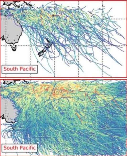
Figure 1: Overview of tropical cyclone tracks in IBTrACS and the STORM dataset (Extract from Bloemendaal et al., 2020). The top panel represents 38 years (1980–2018) of tracks in the IBTrACS dataset, the bottom panel represents a random period of 1,000 years of tropical cyclone tracks in the STORM dataset. Colours indicate the maximum wind speed of the tropical cyclone.
Global datasets such as the Climate Stewardship IBTrACS archive provide the most comprehensive record of past tropical cyclones, but only around 30 recorded events have directly affected New Zealand since the 1950s, far too few to capture the full spectrum of possible impacts.
While historical datasets remain valuable for analysing past cyclone events and understanding long-term trends, synthetic datasets offer complementary advantages that support more comprehensive and dynamic analyses.
Synthetic tropical cyclone datasets are artificially generated collections of storms created using statistical models or physics-based simulations to represent many possible cyclone events including rare and extreme events that have yet to be observed.
As New Zealand experiences an increase in impactful ex-tropical cyclones, there is a growing need for a synthetic storm/cyclonic database tailored specifically to the country's unique geographical and climatic characteristics. This work would incorporate regional factors, such as local sea surface temperatures, atmospheric conditions, and topographic features, to accurately simulate cyclone development and behaviour within the country's context.
MetOcean Solutions has undertaken some preliminary analysis using the global synthetic tropical cyclone hazard STORM dataset (Bloemendaal et al. 2020) which statistically extend the historical dataset to an equivalent of 10,000 years of cyclonic activity (see Figure 1) . A simple parametric wave-generation approach is then applied to derive gridded wave-parameter return-period values for multiple return periods (as illustrated in Figure 2) from cyclonic wind speeds and radius of maximum wind, following the methodology of Young (1988).
For reference, the forecast significant wave height (Hs) at an offshore site near Whangārei (35.5°S, 176.0°E) indicates the peak event from ex-TC Vaianu may reach approximately 10.5 m this Sunday 12 April 2026, which corresponds broadly to a 100- to 1,000-year cyclonic event based on this gridded database.
The crucial next step is a coordinated national effort and funding to develop this critical synthetic storm and cyclone dataset tailored specifically for New Zealand!!!
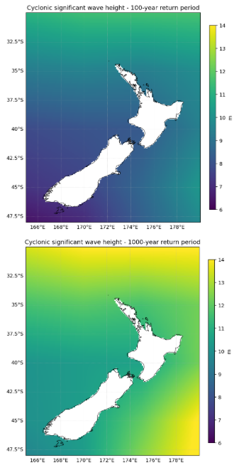
Figure 2: 100-year (top panel) and 1,000-year (bottom panel) gridded cyclonic significant wave height return-period values derived from the synthetic STORM track database, focusing on NZ waters.