
Operational storm surge forecast
Unprecedented flooding of low-lying sections of New Zealand's largest cities occurred over the past weekend, severely disrupting the nation's public transportation system and forcing the shutdown of the country's international and domestic airports.
New Zealand's oceans have played their part in exacerbating these impactful events, including the oceans being warmer than ever before around New Zealand in response to climate change (check the Moana Project news on extreme marine heatwave) and storm tides worsening the flood conditions experienced.
A warmer ocean means that there is more energy available to fuel these storms, with the atmosphere able to hold increasing levels of moisture. Around New Zealand up to 10 –25% more moisture is available for storms to gather up and rain on nearby land due to elevated ocean temperatures (see more information here).
Source: Wild weather washes over Auckland by NZ Herald at https://www.nzherald.co.nz/video/watch-wild-weather-washes-over-auckland/IPNOXMQ4GOZJCVGIDPPVQJ2W5I/
Although the region's heavy rainfall has been the primary cause of the floods, it has been determined that rising water levels brought on by storm tides (high tide, storm surge, and coastal setup) worsen the issue during peak periods.
A storm surge occurs when the sea rises as a result of wind and atmospheric pressure changes associated with a storm. The surges build up over time and will often worsen when a low-pressure system lingers.
Storm surge combined with waves, as well as leading to coastal erosion, can cause significant damage to low lying infrastructure, including roads and coastal properties. The elevated hydraulic head associated with storm tides can lead to wastewater pipes, rivers, and lakes being unable to discharge effectively, resulting in flood conditions persisting for longer and exacerbating the impact of these extreme events.
These extreme events can be expected to become more common as increased global ocean temperatures provide more fuel to energise these systems and New Zealand's climate changes (figure below).
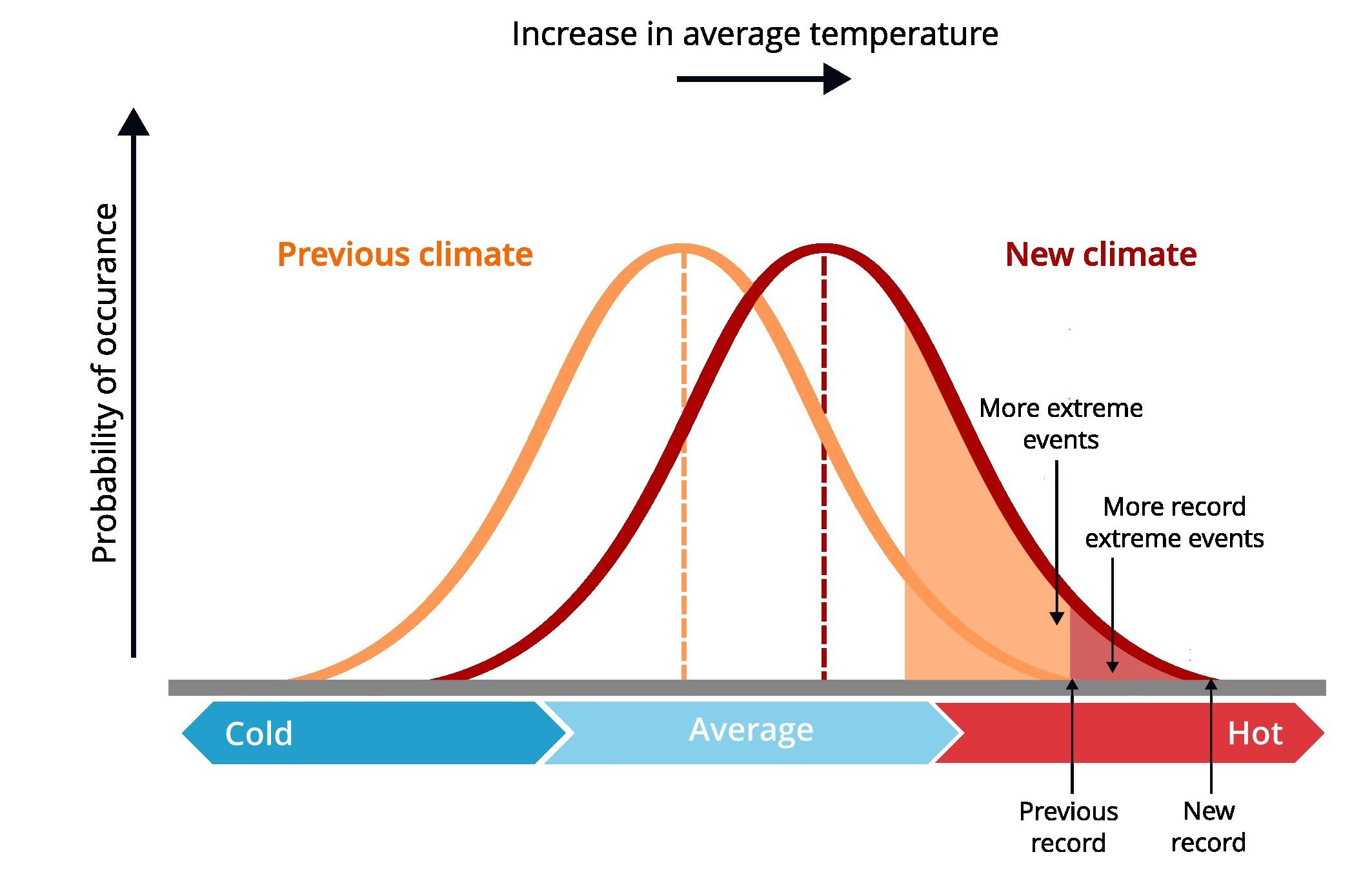
Figure modified from IPCC 2007.
Understanding the link between the ocean and atmosphere is a key part of what we do within MetOcean and MetService, providing New Zealand and our customers with the most accurate and relevant information they need to make informed decisions. This includes operating national scale ocean models that accurately predict the ocean temperature (which then feeds into our atmospheric models), storm tides, and waves around New Zealand – making these data not only available to our expert forecasters in Wellington, but also to clients like the regional councils and port authorities.

Example of operational storm tide forecast available at MetOceanView. Storm tide is the total sea surface height during a storm, resulting from the combination of storm surge and tide.
Contact us at enquiries@metocean.co.nz for more information about Storm Surge forecast.