
StormWatch helps coastal management
MetOcean’s StormWatch supports Regional Councils and marine operators with the safe management of our coasts.
StormWatch is an innovative, automated service based on wave and atmospheric ensemble forecast models. It issues safety warnings to key stakeholders (i.e., regional and district councils) about events that have the potential to cause damage to coastal infrastructure and put people and property at risk.
An ensemble model is the combination of several numerical model simulations using statistical methods. This technique consists of running different numerical models of the same system or running the same model with changes to key input parameters. Because there are a lot of models running at the same time, the resulting forecasts’ divergence allow us to gain an idea of confidence in the forecasts.
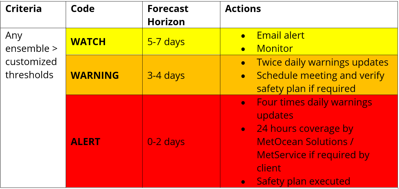
Example of a StormWatch programme.
StormWatch has an automated system that allows us to customise warnings based on various predicted parameters to suit your specific requirements, including; wave heights, wave periods, wave direction, wave water levels, wind speeds and wind direction Boolean logic (A form of logical algebra which works only with two values, true or false). Once a certain threshold is exceeded by one of the elements, the automated system tracks the event as it evolves in the forecast window, with initial Watches being issued via a customisable email distribution list 5-7 days out, followed by Warnings (3-4 days) and finally Alerts (0-2 days). If an event changes over the course of the forecast and drops below the specified threshold, the automated StormWatch system issues an OK email.
By tracking these significant events, stakeholders can be warned and advised of a developing situation by the forecast and can plan and implement appropriate responses. Rather than having experienced maritime forecasters engaged 24/7, this service allows stakeholders to leverage the marine forecasting expertise within MetOcean and MetService at a fraction of the cost.
An ensemble forecast allows us to quantify the uncertainty in longer-range forecasts and provide probabilistic guidance for management decisions. The method estimates, for example, extreme maximum individual wave height, by accounting for the long-term uncertainty of the severity of the environment, and the short-term uncertainty of the severity of the maximum wave of a given sea state, complying with the International Organization for Standardization (ISO standards).
Combined with accurate high-resolution wave models that capture local wave transformation such as SWAN (Simulating WAves Nearshore), the ensemble forecasts provide the best possible site-specific warning of upcoming severe conditions.
Up to 60 wave ensemble forecasts can be used to support a StormWatch programme.

Example of StormWatch alert email.


StormWatch guidance. Red shading indicates when the alerting thresholds are exceeded.
MetOcean Solutions can customise the forecast warning system, StormWatch, for any nearshore or offshore location based on 7-day forecast wind speed, significant wave height (Hs) and maximum individual wave height (Hmax).
For more information about StormWatch, contact us at enquiries@metocean.co.nz.