
Drifting Wave Buoy Rides the Waves of Cyclone DOVI
A MetOcean wave buoy drifting in the Tasman Sea found itself close to the center of the ex-tropical cyclone Dovi, as it moved across New Zealand on Sunday the 13th of February 2022. The wave buoy measured significant wave heights (Hs) of 7.5 meters at the highest.
Back in the office after the storm, our expert wave modeller, Dr Henrique Rapizo, could not wait to have a look at the observational data from the wave buoy and compare it to our model data.
“The storm offered an opportunity to validate our inhouse wave models,” explains Dr Rapizo. “Validation is when we compare the model results directly with real time measurements, which provides us with a clear indication of how well models predict the timing and the magnitude of extreme storms.”
The animation below illustrates the path of the wave buoy and the significant wave heights as the system moves close to the west coast of the North Island, while co-plotting the measured and forecasted wave heights (see Figure 1).
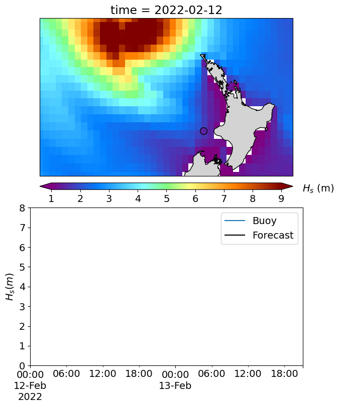
Figure 1. Observational data from the drifting MetOcean wave buoy plotted against our forecasted wave heights.

Figure 2. A satellite image of Cyclone DOVI near the west coast of North Taranaki/Waitomo on 13 February at 10:30 am, published by MetService (click here)

Figure 3. Surfer riding a 12.8 m wave (Image from www.worldrecordacademy.org).
“The wave height comparison was excellent for a such rapidly moving system. The forecast timing and height of the waves were well correlated with the measured storm values. The buoy measured a highest significant wave height of 7.5 m, while the corresponding forecasted value was 7.2 m (and maximum wave height - Hmax of 10.72 m). The greatest forecasted Hs was 13.5 m on 11th of February at noon (UTC), when the storm was closer to its origin many miles north of New Zealand at latitude 28.5°S.
“It is very encouraging to see the models perform with such precision under these extreme storm conditions,” adds Dr Rapizo. “This animation is an honest representation of forecast accuracy and allows users to gain confidence in the timing and magnitude of the wave predictions.”
These operational models are produced by MetOcean Solutions for a range of applications in New Zealand waters. The models are tuned to replicate the typical conditions, so verifying the predictions under an extreme storm is a powerful test.
Through our web portal MetOceanView, MetOcean Solutions provide automated forecast services for coastal and offshore operators. MetOceanView ingests observations from over 10,000 sites every day, including over 250 locations around New Zealand.
For queries about MetOcean’s operational forecast, contact enquiries@metocean.co.nz.